If you’re heading to Yosemite National Park and wondering where to start, you really can’t go wrong exploring the best hikes in Yosemite Valley. 😍
This is the heart of the park where you’ll find massive waterfalls, jaw-dropping cliffs, and some of the most iconic views in the world!
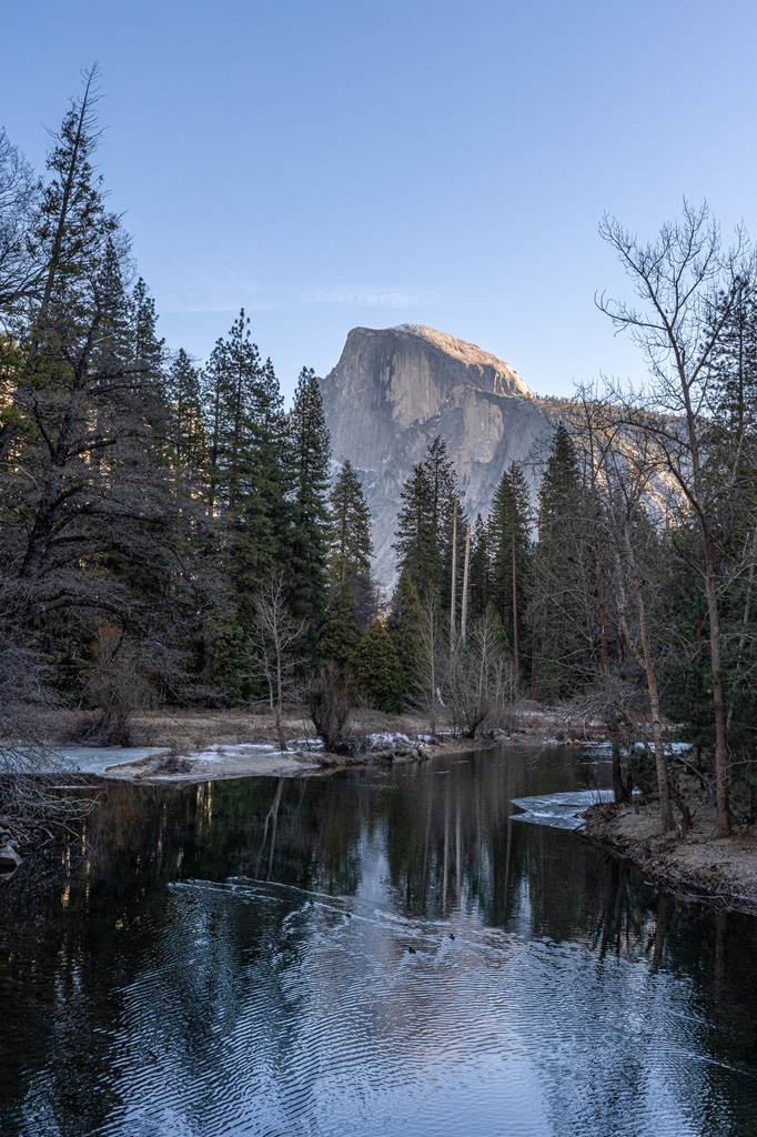
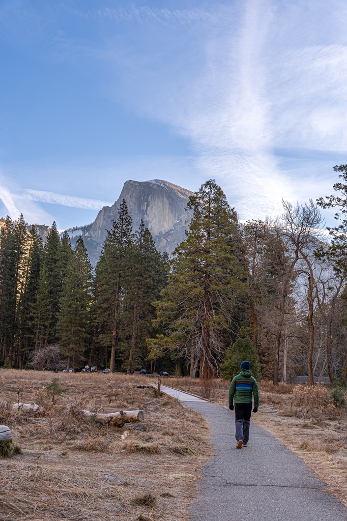
Yosemite Valley is where the magic happens. You’ve probably already seen photos of El Capitan, Half Dome, and Yosemite Falls, but trust me, seeing them in person is on a whole different level.
Want to know the best part? You can see many of the iconic landmarks along with incredible views no matter which trail you choose! 🙌
From peaceful riverside strolls to steep switchbacks that’ll test your legs and lungs, hikes in Yosemite Valley offer a little bit of everything.
No matter your experience, fitness level, or whether it’s your 1st visit or 10th visit to Yosemite, there’s a trail for you! 🥾
Affiliate Disclaimer: Some links on this page may be affiliate links, meaning I may earn a small commission at no extra cost to you. As an Amazon Associate, I earn from qualifying purchases. Thanks for supporting the blog! 🫶
Easy Hikes in Yosemite Valley
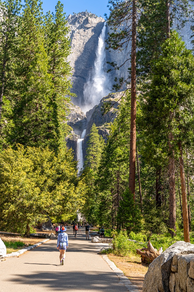
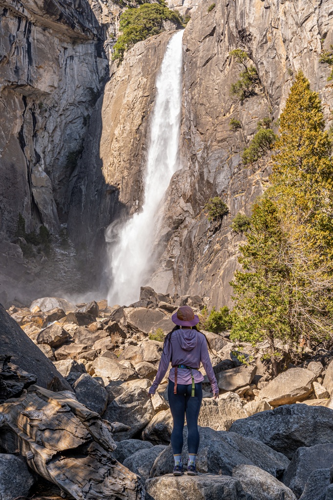
1. Lower Yosemite Fall Trail
Starting Point: Lower Yosemite Fall Trailhead (shuttle stop #6)
Length: 1.2 miles roundtrip
Elevation Gain: 55 feet
Hiking Time: 30 minutes
Route Type: Loop
Pet-friendly? Yes, must be on leash
Hike Features: Viewpoints of Lower Yosemite Fall and the entire Yosemite Falls
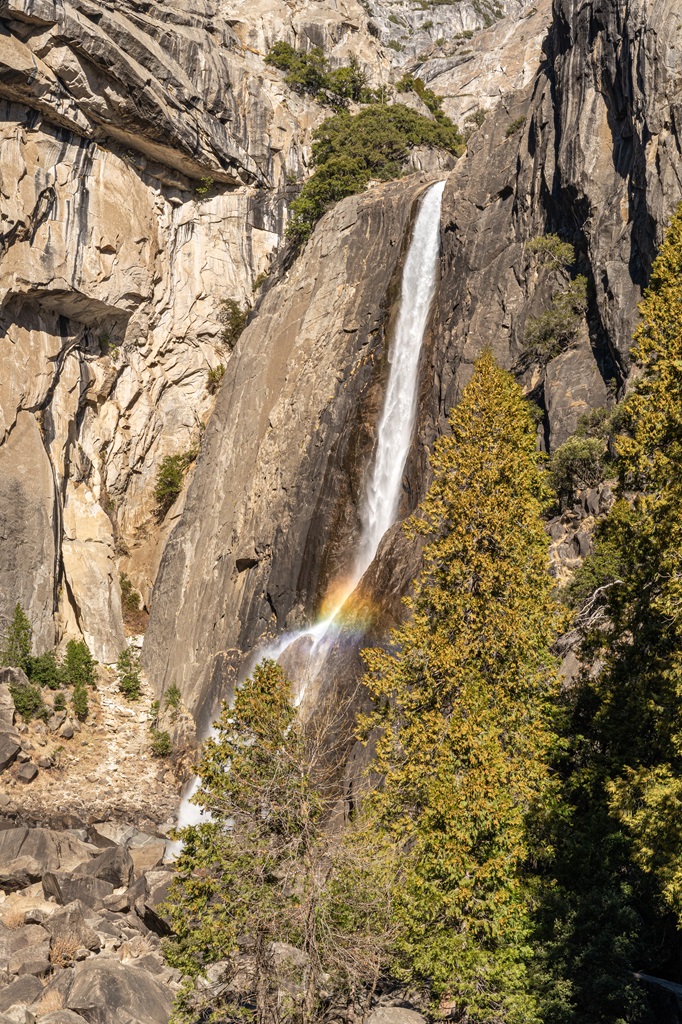
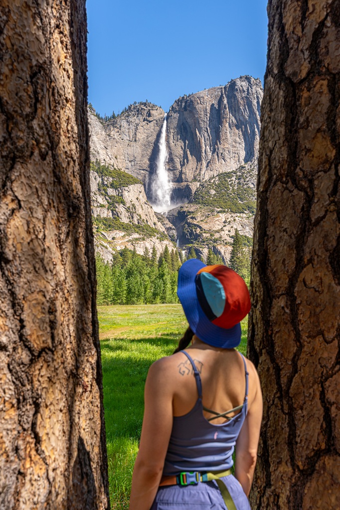
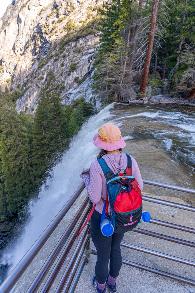
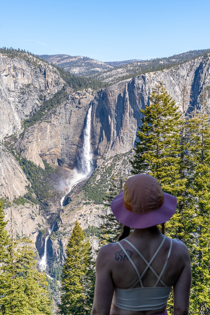
Want to get up close to one of Yosemite’s most iconic waterfalls? The Lower Yosemite Fall Trail takes you right to the base of one of the tallest waterfalls in North America.
Lower Yosemite Fall is 320 feet and is the final drop of Yosemite Falls. This short, easy walk gives you a few awesome views!
From the footbridge, you’ll get an up-close look at the powerful lower cascade. A little farther away, there’s a nice viewpoint to see the full waterfall from top to bottom.
My favorite view is from the western side along the trail as you can see all three cascades of Yosemite Falls!
Just keep in mind there’s no parking right at the trailhead. Your best bet is to park at Yosemite Village or Yosemite Falls parking area.
You can also hop on the Valleywide Shuttle and get off at stop #6 (Lower Yosemite Fall Trailhead) for easy access.
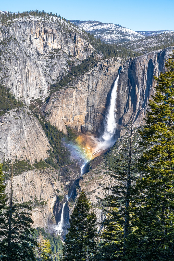
Late spring and early summer are the best times to feel the cool mist blowing off the falls, and if you time it just right, you might even spot a rainbow at the base!
The entire trail is paved but the eastern portion is wheelchair accessible when there’s no snow or ice.
This trail is great for families with young children and leashed pets are allowed!
Restrooms and drinking water are available near the western part of the loop.
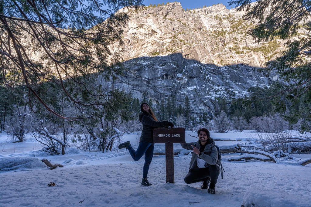
2. Mirror Lake Paved Trail
Starting Point: Mirror Lake Trailhead (shuttle stop #17)
Length: 2 miles roundtrip
Elevation Gain: 110 feet
Hiking Time: 45 minutes
Route Type: Out-and-back
Pet-friendly? Yes, must be on leash
Hike Features: Mirror Lake, view of granite peaks
Mirror Lake is a scenic spot in Yosemite Valley where you can soak in views of calm water and towering granite cliffs.
There are two options for how far you want to go. Right now, I’ll discuss the easier and shorter route – an easy 2-mile out-and-back walk along a paved road.
The paved path is open to leashed pets, bikes, and strollers, and it’s also wheelchair accessible.
There’s no parking right at the trailhead, but the closest parking lots are at Curry Village or the Yosemite Valley Trailhead Parking. Or just catch the shuttle and hop off at stop #17.
There’s no drinking water at the trailhead or along the trail, so definitely bring your own. Vault toilets are available about half a mile from the start and also at the lake.
Once you reach Mirror Lake, you will be rewarded with stunning views of Half Dome, Mount Watkins, and Washington Column.
3. Cook’s Meadow Loop
Starting Point: Cook’s Meadow Loop Trailhead, Sentinel Bridge Parking Area, or Lower Yosemite Fall Trailhead
Length: 1 mile roundtrip
Elevation Gain: 30 feet
Hiking Time: 20 to 30 minutes
Route Type: Loop
Pet-friendly? Yes, must be on leash
Hike Features: Beautiful meadow, views of Yosemite Falls, Half Dome, Glacier Point, Sentinel Rock, and other granite peaks
✨ READ THIS: 10 Easy Hikes in Yosemite National Park
One of my favorite spots in Yosemite Valley has to be Cook’s Meadow (also known as Sentinel Meadow). It’s peaceful, scenic, and packed with iconic views.
This easy 1-mile loop takes you through open meadow with jaw-dropping views of Yosemite Falls, Half Dome, Glacier Point, and Sentinel Rock.
For one of the best photo ops in the park, head to Sentinel Bridge. You’ll get a postcard-worthy shot of Half Dome reflected in the Merced River.
The trail is mostly flat and easy, and it’s wheelchair accessible when it’s not snowy or icy. Leashed pets, bikes, and strollers are also welcome here.
Just make sure to stay on the marked path to help protect the meadow. It’s a fragile ecosystem!
There’s a small parking area near Sentinel Bridge off Sentinel Drive, but it fills up fast, especially in peak season. Your best bet is usually to park at Yosemite Village or the Yosemite Falls parking area.
During the busy months, you might need to hop on the Valleywide Shuttle to get there. Convenient stops nearby include #1 (Yosemite Village), #5 (Yosemite Exploration Center), and #6 (Lower Yosemite Fall Trailhead).
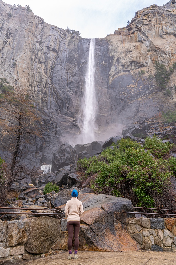
4. Bridalveil Fall Trail
Starting Point: Bridalveil Fall Trailhead or parking off Southside Drive
Length: 0.5 to 1 mile roundtrip
Elevation Gain: 80 to 115 feet
Hiking Time: 20 to 30 minutes
Route Type: Out-and-back
Pet-friendly? Yes, only on the Bridalveil Fall Trail (not on the Valley Loop Trail)
Hike Features: Bridalveil Fall Viewpoint
Bridalveil Fall is one of Yosemite’s most iconic waterfalls! You can spot it from classic viewpoints like Tunnel View and Valley View.
It drops an impressive 620 feet and is often one of the first waterfalls you’ll see as you enter Yosemite Valley.
Want to get up close? You’ve got two easy options to reach the base of the falls:
- Take the short 0.5-mile roundtrip walk from the main trailhead. It’s paved and wheelchair accessible.
- Or, if you’re up for a slightly longer stroll, start from further down Southside Drive for a 1-mile roundtrip hike.
The paved trail from the main trailhead is pet-friendly (just keep your furry friend leashed), but the Southside Drive route is not as it follows the Valley Loop Trail.
The main parking lot holds around 60 vehicles. There’s more parking just a bit farther along Southside Drive on both sides of the road.
One thing to note: there’s no shuttle service to Bridalveil Fall, so you’ll need to drive yourself. Also, restrooms are available at the main parking area.
Moderates Hikes in Yosemite Valley
5. Mirror Lake Loop
Starting Point: Mirror Lake Trailhead (shuttle stop #17)
Length: 5 miles roundtrip
Elevation Gain: 300 feet
Hiking Time: 2 to 3 hours
Route Type: Loop
Pet-friendly? No, pets are not allowed
Hike Features: Mirror Lake, Tenaya Creek, and views of granite peaks
There are two ways to enjoy the hike to Mirror Lake, depending on how much time and energy you’ve got.
The easier option is a 2-mile out-and-back walk along a paved path (discussed above). It’s a relaxing stroll with views of the granite cliffs and a nice reflection of the surrounding peaks.
If you’re up for more of an adventure, the full 5-mile loop is a great way to explore the area.
This route takes you all the way around Mirror Lake, following Tenaya Creek, crossing a couple of bridges after the Snow Creek Trail junction, and looping back along the south side of Tenaya Canyon.
It’s mostly easy, but a few moderate sections pop up, especially in spring when melting snow can flood parts of the trail.
Mirror Lake usually has the most water in spring and early summer, thanks to snowmelt feeding Tenaya Creek.
That’s when you’ll catch those dreamy reflections. Later in the year, the lake shrinks quite a bit, but the hike is still totally worth it for the views.
There’s no parking right at the trailhead, but nearby lots at Curry Village and Yosemite Valley Trailhead Parking are good options. You can also take the free Valleywide Shuttle and get off at stop #17.
Make sure to bring water! There’s none available at the trailhead or on the trail. Also, vault toilets are located about half a mile in and at the lake itself.
6. Valley Loop Trail
Starting Point: Lower Yosemite Fall Trailhead (shuttle stop #6)
Length: 7.2 (half loop) to 11.5 miles (full loop) roundtrip
Elevation Gain: Minimal elevation gain
Hiking Time: 4 to 7 hours
Route Type: Loop
Pet-friendly? No, pets are not allowed
Hike Features: Iconic Yosemite landmarks, Merced River, and meadows
The Valley Loop Trail is a mostly flat hike winding through quiet meadows, shady forests, and along the Merced River, with stunning views of Yosemite Falls, El Capitan, Bridalveil Fall, Cathedral Rocks, Sentinel Rock, the Three Brothers, and more.
It follows some of the park’s original east-west wagon roads, giving it a bit of old-school Yosemite charm.
You can start the hike in lots of places throughout the Valley, but a common starting point is near the Lower Yosemite Fall Trailhead (shuttle stop #6).
From there, you’ll head west past Camp 4 and the base of the Three Brothers toward El Capitan. Simply follow the trail signs to make an 11.5-mile loop around the Valley floor.
For a shorter loop (7.2 miles), cross the Merced River at El Capitan Bridge and head back toward Yosemite Village.
AllTrails has a much longer route (20.3 miles) which includes the loop around Mirror Lake, so this is a great option if you’re looking for a bigger adventure.
The trail’s terrain is a mix of dirt, sand, rocks, and some old pavement, with a few mild ups and downs.
In spring, you might run into some flooding near creeks, and in winter, icy or snow-covered sections can make things tricky, especially on the south side of the Valley.
There’s no drinking water along the trail, so fill up at the fountain near the Lower Yosemite Fall Trailhead.
Restrooms are available at the start, at Bridalveil Fall, and at picnic areas along the way.
Parking isn’t available right at the trailhead, but you can park at Yosemite Village or Yosemite Falls parking area.
The Valleywide Shuttle is super helpful, with stops at #6 (Lower Yosemite Fall Trailhead), #9 (El Capitan Meadow), and #11 (Four Mile Trailhead).
Challenging Hikes in Yosemite Valley
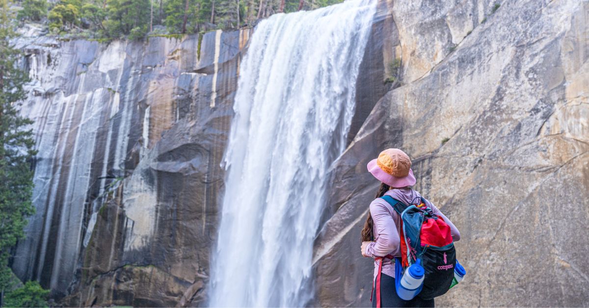
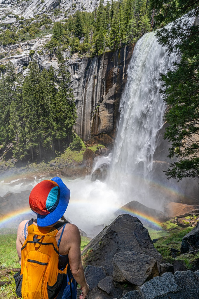
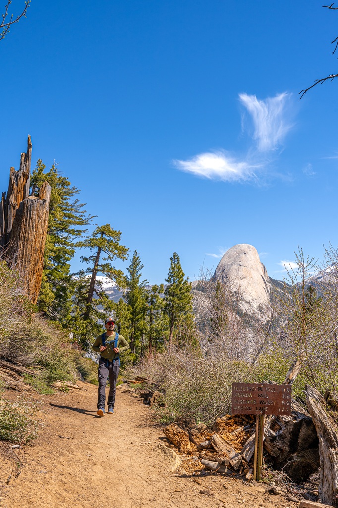
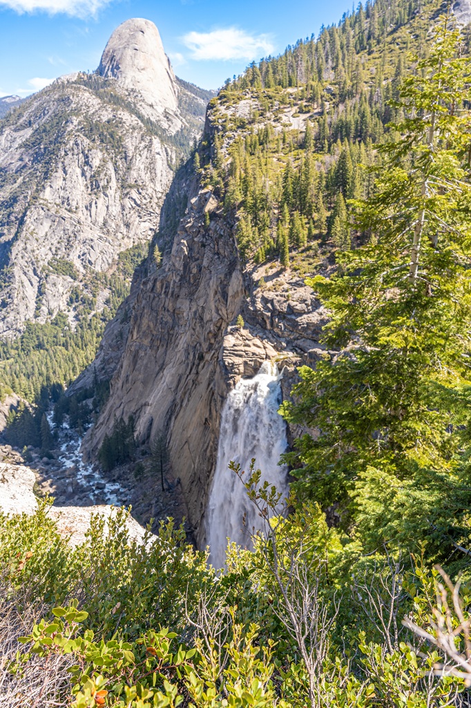
7. Mist Trail and John Muir Trail Loop to Vernal Fall and Nevada Fall
Starting Point: Happy Isles (shuttle stop #16)
Length: 7 miles
Elevation Gain: 2,200+ feet
Hiking Time: 5 to 6 hours
Route Type: Loop
Pet-friendly? No, pets are not allowed
Hike Features: Vernal Fall, Nevada Fall, Clark Point (stunning views), Liberty Cap, multiple footbridges
✨ READ THIS: Vernal Fall and Nevada Fall Hiking Guide
If you’re planning to hike to both Vernal and Nevada Falls, the Mist Trail and John Muir Trail Loop is the best route. It’s the ultimate Yosemite waterfall adventure!
It’s got everything, including heart-pounding climbs, nonstop views, and two of the most iconic waterfalls in the park.
This loop combines the steep, misty, and dramatic Mist Trail with the more gradual, scenic switchbacks of the John Muir Trail.
You will first go up the Mist Trail for a close-up of Vernal and Nevada Falls, then come down the John Muir Trail for big views and a less punishing descent.
The best time to hike this route is in late spring or early summer when the waterfalls are at their peak flow and roaring. It’s an incredible experience!
☃️ Winter Closures: Keep in mind that the lower Mist Trail (the steep steps beside Vernal Fall) and the upper section of the John Muir Trail (from Clark Point to top of Nevada Fall) are closed in winter due to ice and rockfall danger.
Even when parts of the trail are open, winter hiking can be icy and slippery, especially in shaded areas. Always check the latest trail conditions before heading out!
There is a winter route available to access Vernal and Nevada Falls. It begins following the Mist Trail as normal, then you’ll take the lower section of the John Muir Trail, hop on the Clark Point cutoff to reach Vernal Fall, then get onto the upper section of the Mist Trail to reach the top of Nevada Fall.
✨ READ THIS: 20 Best Yosemite Hikes in Winter
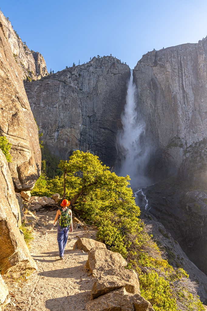
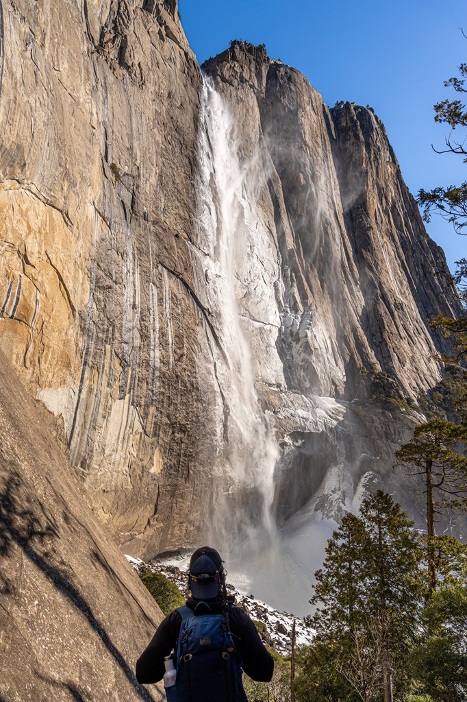
8. Upper Yosemite Fall Trail
Starting Point: Upper Yosemite Fall Trailhead (shuttle stop #7)
Length: 7 miles
Elevation Gain: 3,200 feet
Difficulty: Challenging
Hiking Time: 4 to 8 hours
Route Type: Out-and-back
Pet-friendly? No, pets are not allowed
Hike Features: Columbia Rock, different angles of Yosemite Falls, Yosemite Falls Overlook, and insane views of the valley
✨ READ THIS: Upper Yosemite Fall Hiking Guide
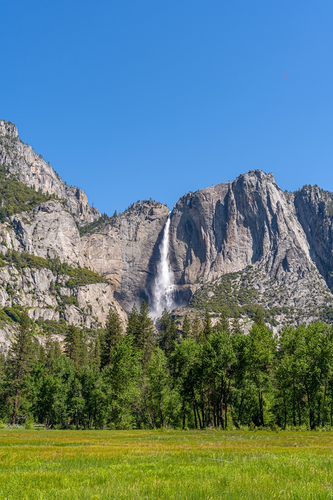
Yosemite Falls is one of the tallest waterfalls in North America, dropping an impressive 2,425 feet from top to bottom.
It’s made up of three sections: the massive Upper Yosemite Fall (1,430 feet), the Middle Cascades (675 feet), and the shorter but still stunning Lower Yosemite Fall (320 feet).
If you’re up for a challenge, the Upper Yosemite Fall Trail is one of the most rewarding hikes in the park. The trail climbs steeply from the valley floor up to the top of the falls, gaining over 3,000 feet in just 3.5 miles (roundtrip).
It’s a tough workout, with steep switchbacks, rocky sections, and serious elevation gain but the views are absolutely worth it!
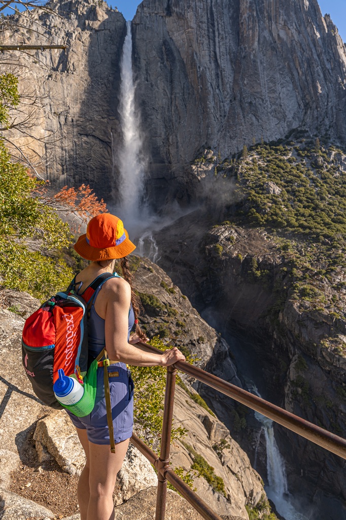
Along the way, you’ll get incredible views of Yosemite Falls, Yosemite Valley, Half Dome, and more stunning granite peaks.
If you’re up for a slightly longer adventure, hike an extra mile to reach Yosemite Point for even more jaw-dropping scenery!
The Upper Yosemite Fall Trailhead is located near Camp 4. Look for the sign at the back left corner of the Camp 4 parking area.
🚍 Parking near the trailhead can be tough, especially during peak season, but the free shuttle system makes it easy. Just hop off at stop #7, and you’re right there.
✨ READ THIS: Best Yosemite Waterfalls You Can’t Miss!
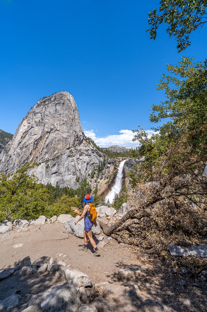
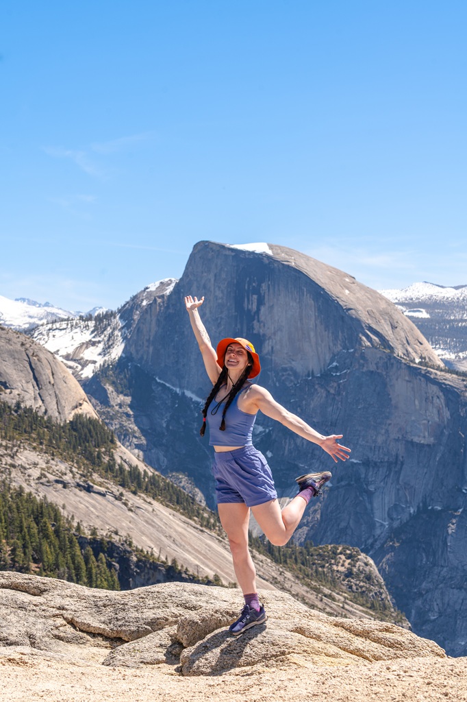
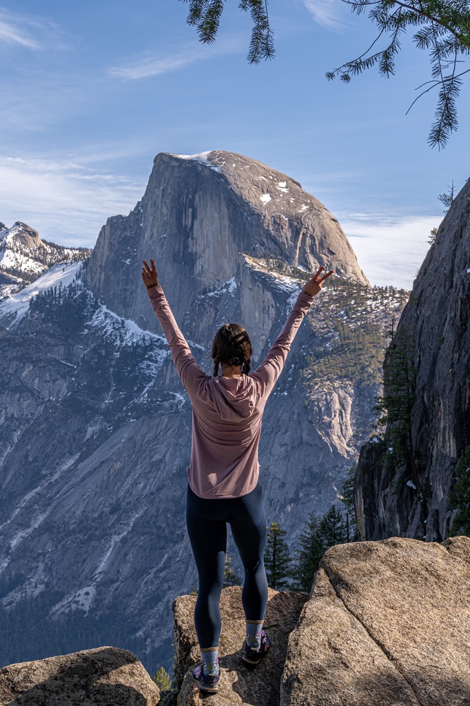
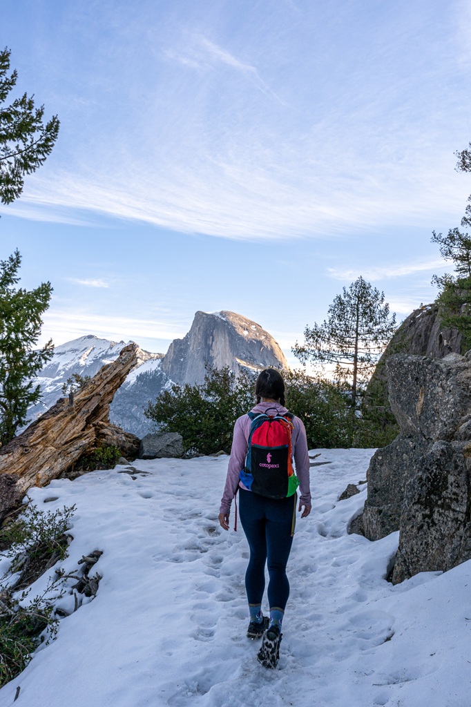
9. Half Dome
Starting Point: Happy Isles (shuttle stop #16)
Length: 14 (Mist Trail) to 16.5 (JMT) miles roundtrip
Elevation Gain: 5,305 feet
Hiking Time: 8 to 12 hours
Route Type: Out-and-back
Pet-friendly? No, pets are not allowed
Hike Features: Vernal Fall, Nevada Fall, incredible views, Sub Dome, infamous cables, and Half Dome
Half Dome is one of Yosemite’s most iconic and challenging hikes, climbing nearly 5,000 feet from the Valley floor to incredible views of Vernal and Nevada Falls, Yosemite Valley, and the High Sierra.
You’ll need a permit to summit, and it typically takes 10–12 hours roundtrip, so plan for an early start and a full day of hiking.
The route follows the Mist Trail (or John Muir Trail) past two major waterfalls, then levels out through Little Yosemite Valley before steep switchbacks lead you to Sub Dome.
From there, you’ll meet the famous Half Dome cables – a 400-foot, near-vertical climb with steel cables to help you up.
It’s intense, exposed, and unforgettable. Gloves and a good grip are a must! Some hikers also use harnesses for extra safety.
At the top, take your time and enjoy the 360° views.
On the way down, you can return via the Mist Trail or take the slightly longer John Muir Trail for a change of scenery.
Water refills and restrooms are available at the Vernal Fall footbridge.
10. Four Mile Trail
Starting Point: Four Mile Trailhead (shuttle stop #11)
Length: 9.8 miles roundtrip
Elevation Gain: 3,420 feet
Hiking Time: 6 to 8 hours
Route Type: Out-and-back
Pet-friendly? No, pets are not allowed
Hike Features: Epic views (El Capitan, Half Dome, Cathedral Rocks, Yosemite Falls, Tenaya Canyon), Union Point, unnamed viewpoint, and Glacier Point
✨ READ THIS: Four Mile Trail Hiking Guide
The Four Mile Trail is a Yosemite favorite but heads up, it’s actually closer to five miles one-way. Still, it’s 100% worth the effort.
This steep, switchback-heavy trail climbs over 3,400 feet from the Valley floor all the way up to Glacier Point.
Along the way, you’ll get nonstop jaw-dropping views of El Capitan, Cathedral Rocks, Sentinel Rock, Yosemite Falls, and Half Dome.
It was originally built as a toll route in 1872 (when it was four miles), but a later reroute added a bit more distance.
A portion or the entire Four Mile Trail is closed in winter due to hazardous conditions from snow and ice. Always check the trail conditions before heading out, especially if hiking in the winter or spring!
There’s a tour bus (reservations required) that runs from Yosemite Valley to Glacier Point, which is a great option if you want to hike down the Four Mile Trail one-way.
But if you’re hiking up from the Valley to Glacier Point, be sure to arrange a ride ahead of time if you don’t plan on hiking back down. There’s no free shuttle service from the top!
The trailhead is on the south side of Yosemite Valley off Southside Drive between Swinging Bridge and Sentinel Beach. Look for the “Four Mile Trail” sign or hop off the free Yosemite shuttle at stop #11.
Parking is available at the trailhead, but it fills up fast. There are more parking spots at the Swinging Bridge Picnic Area along with vault toilets.
Glacier Point also has vault toilets and drinking water (seasonal).
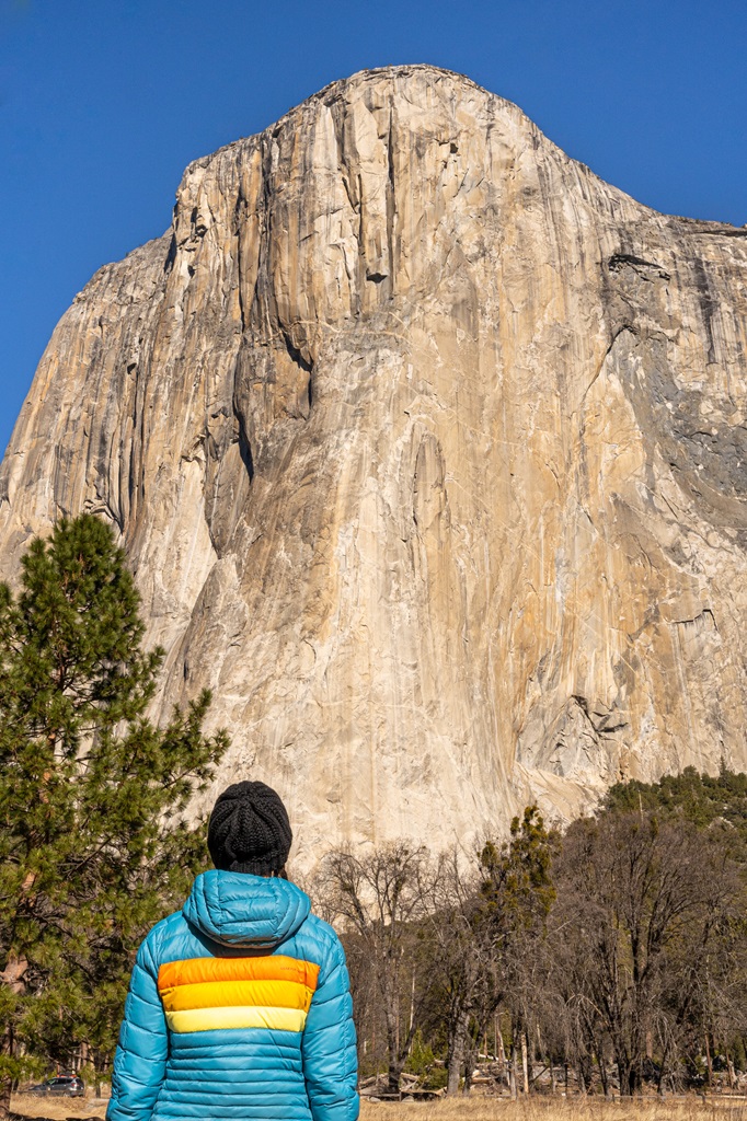
11. El Capitan from Yosemite Valley
Starting Point: Upper Yosemite Fall Trailhead (shuttle stop #7)
Length: 16 miles roundtrip
Elevation Gain: 4,800-5,200 feet (different sources say different things)
Hiking Time: 8-12 hours
Route Type: Out-and-back
Pet-friendly? No, pets are not allowed
Hike Features: Upper Yosemite Fall, views of Yosemite Valley, standing on top of the most iconic landmark in Yosemite – El Capitan
✨ READ THIS: El Capitan from Yosemite Valley Hiking Guide
Did you know you can actually hike to the top of Yosemite’s most iconic granite giant without any climbing gear?
That’s right, you can take an easy-to-follow (but not easy on the legs) trail to the top!
Sure, it’s world-famous for its climbing routes, but most people don’t realize there’s an official hiking trail that takes you all the way to the top.
This hike isn’t for the faint of heart. It’s long, steep, and seriously demanding but the views from the top? 100% worth it.
The trail starts at the Upper Yosemite Fall Trailhead, which you’ll find near Camp 4. Look for the trail sign at the back left of the Camp 4 parking area.
Taking the shuttle? Hop off at Stop #7 (Camp 4/Yosemite Falls) for easy access.
🅿️ Parking near the trailhead:
- Yosemite Falls parking area is right across the street and your best bet if spots are open.
- Yosemite Village parking area is a bit farther, about a 1.5-mile walk or a quick shuttle ride to the trailhead.
- Camp 4 parking is only for registered campers, so unless you’re lucky enough to snag a campsite, don’t count on parking there.
If you’re up for the challenge and come prepared, hiking to the top of El Cap is one unforgettable adventure!
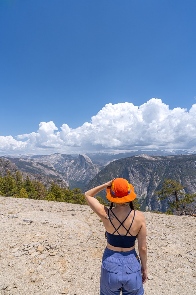
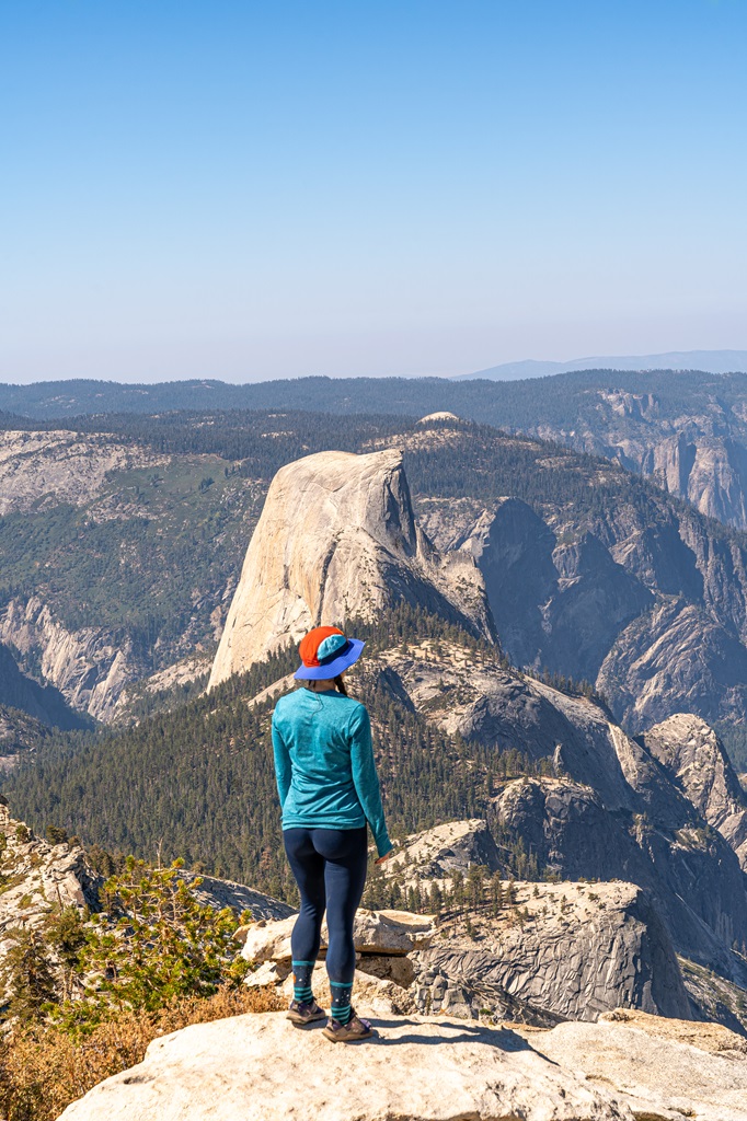
12. Clouds Rest from Yosemite Valley
Starting Point: Happy Isles (shuttle stop #16)
Length: 20 miles roundtrip
Elevation Gain: 6,200 feet
Hiking Time: 11 to 13 hours
Route Type: Out-and-back
Pet-friendly? No, pets are not allowed
Hike Features: Vernal Fall, Nevada Fall, Clouds Rest, and beautiful views along the way
✨ READ THIS: Clouds Rest Hiking Guide
At 9,926 feet, Clouds Rest is one of Yosemite’s most epic and underrated summits.
It actually towers over Half Dome by more than 1,000 feet, and the views from the top are unreal! You’ll get a sweeping 360-degree panorama that includes Half Dome, Tenaya Canyon, Yosemite Valley, and distant Sierra Nevada peaks.
The most popular way to reach Clouds Rest is to start from the Sunrise Lakes Trailhead off Tioga Road.
This route is 14.5 miles roundtrip with 3,100 feet of elevation gain. It’s a tough hike but not as intense as starting from the Valley.
The route from Yosemite Valley is a long, tough haul, but totally worth it. You’ll start at the Mist Trail/John Muir Trail Trailhead, heading up either the Mist Trail or the John Muir Trail, passing the iconic Vernal and Nevada Falls.
From there, the trail climbs through Little Yosemite Valley and eventually connects with the Clouds Rest Trail.
The final stretch to the summit features a narrow ridge with some exposure, so take your time and watch your footing. But once you reach the top, the views are pure magic!
It’s about 20 miles roundtrip with 6,000+ feet of elevation gain – a serious challenge even for seasoned hikers.
If you didn’t score Half Dome permits, this hike is an amazing alternative, and some would say the views are even better. 😉
✨ Headed to Yosemite’s high country? Read my ultimate Tioga Pass guide to plan the perfect trip!
13. Mist Trail and Panorama Trail + Four Mile Trail
Starting Point: Happy Isles (shuttle stop #16)
Length: 14 miles roundtrip
Elevation Gain: 4,000+ feet
Hiking Time: 8 to 10 hours
Route Type: Point-to-point
Pet-friendly? No, pets are not allowed
Hike Features: Vernal Fall, Nevada Fall, Panorama Point, Illilouette Fall, Illilouette Creek, Glacier Point, and amazing views of Yosemite Valley
✨ READ THIS: Panorama Trail (+ Four Mile Trail) Hiking Guide
This is one of my favorite hikes in all of Yosemite National Park! It’s challenging but super beautiful. So much scenery packed into 14 miles!
A lot of people prefer to go up the Mist Trail and Panorama Trail then down the Four Mile Trail.
Hiking up the Mist Trail and the last portion of the Panorama Trail will be challenging. But the views the entire way up and down will be worth every step!

This is a point-to-point hike. Once you reach the Four Mile Trailhead, you can then take the shuttle back to wherever you parked your car.
The AllTrails map for this route begins in the opposite direction – ascending on the Four Mile Trail to Glacier Point then descending on the Panorama Trail and Mist Trail.
Like I mentioned above, most people recommend starting on the Mist Trail, but you can do this hike whichever way sounds good to you!
Best Time to Hike Trails in Yosemite Valley
🌷 Spring (March – May): Spring might be the absolute best time to hike in Yosemite Valley!
The weather is mild (not too cold, not too hot), the summer crowds have not arrived yet, and by late spring the waterfalls are at their peak flow. I would prioritize waterfall hikes during this time, especially in late May and early June.
Just be aware that in early to mid-spring you may encounter lingering snow from the previous winter season at higher elevations above the valley. Always be prepared with the appropriate gear and check trail conditions before heading out!
☀️ Summer (June – August): Summer is peak time! That’s when everyone and everybody heads to Yosemite National Park. In my personal opinion, this isn’t the most ideal time to hike in Yosemite Valley.
Be prepared for hot temperatures in the valley, crowded trails, lots of traffic, and bugs! Don’t get me wrong, hiking in the summer can be an excellent time if done right.
Here’s a few quick tips: start early, pack plenty of water and snacks, use sun protection, and know your limits. Hiking in the summer heat can be dangerous if you’re not prepared.
In the summer, my husband and I prioritize heading to Tioga Road to hike in the high country where the temperatures are cooler, the crowds are not as crazy as the valley, and the views are just as stunning!
🍂 Fall (September – November): Fall can be a nice time to hike in Yosemite Valley. The temperatures are cooler, the summer crowds are gone, and the landscape changes so beautifully with fall colors.
If you want to see the fall colors at their peak, try to go in late October to early November.
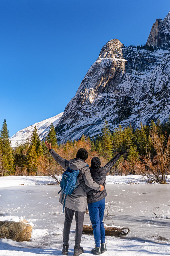
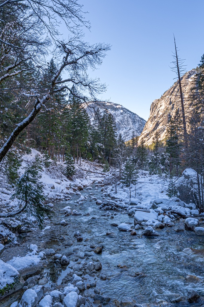
🌨️ Winter (December – February): Winter in Yosemite Valley is such as underrated time to go hiking! This is my second favorite season to hike trails in the valley.
Seeing trails, trees, viewpoints, and granite peaks, all covered in snow just makes my heart so happy! It’s a very beautiful time to be outside but also a dangerous time if you’re not prepared with proper gear and route finding skills.
If you’re new to winter hiking in Yosemite, I recommend sticking to the easier hikes on the valley floor. And if you’re more skilled and experienced, then tackle some of the hikes that head up to the valley rim. Just make sure you’re prepared!
❄️ Yosemite Winter Guides
- Ultimate Guide to Visiting Yosemite in Winter
- The Only Yosemite Winter Itinerary You Need!
- Where to Stay in Yosemite in Winter: 15+ Best Lodges, Hotels, and Cozy Cabins
- The Ultimate Yosemite Winter Packing List
- 20 Best Yosemite Hikes in Winter (Guide to Snowy Adventures)
- 18 Best Yosemite Winter Activities You Can’t Miss!
- Yosemite Firefall: A Complete First-Timer’s Guide
- Beginner’s Guide to Visiting Mariposa Grove in Winter
Tips for Hiking in Yosemite Valley
1. Yosemite’s Entrance Fee and Reservation:
Entrance to Yosemite National Park costs $35 per vehicle for a 3-day pass. However, if you have the America the Beautiful Annual Pass, your entry is free!
For those who love exploring national parks, investing in the Annual Pass is a smart choice. At just $80, for U.S. residents, it grants you access to over 2,000 federal recreation sites across the country!
FEE UPDATES! Beginning January 1, 2026, non-U.S. residents (without an annual pass) will pay a $100 per person in addition to the standard entrance fee. The Annual Pass for non-US. residents will cost $250.
Reservations are not required at this time (updated January 12, 2026).
2. Download Offline Maps: Most of the trails are easy to follow and well-marked, but having offline maps downloaded on your phone can give you peace of mind.
3. Start Early: Beat the crowds and enjoy cooler temperatures by starting your hike early in the morning, especially during peak season.
4. Check the Weather Forecast: Do not attempt to hike any of these trails in inclement weather! I don’t just mean a light rain shower, unless you’re planning to hike Half Dome, but I’m talking about thunderstorms, heavy rain, heavy snow, etc.
Always check the weather forecast and stay alert for dark clouds.
5. Be Bear Aware: Black bears are active within Yosemite. Follow these guidelines to avoid any negative interactions with a black bear.
🐻 Note: bear spray is prohibited in Yosemite!
6. Check Trail Conditions: In the winter as well as the spring and fall, snow fall can result in trail closures as well as dangerous conditions – confirm trails are open before heading out.
Also, read trail reviews and articles to better understand current conditions.
7. Respect Nature: Follow Leave No Trace principles – plan ahead, pack out all trash, avoid disturbing wildlife, be considerate of others, and respect the natural beauty of Yosemite National Park.
What to Bring When Hiking in Yosemite Valley
🎟️ Entrance Pass – You will need to purchase an entrance pass once you reach the entrance station or you can buy the America the Beautiful Pass ahead of time and use that for the entire year.
📆 Reservation – Depending on when you plan to visit Yosemite, you may need a reservation.
👚 Layers of Clothing (top) – Pack a moisture-wicking base layer, a fleece mid-layer, an insulated jacket, and an outer shell to protect you from the elements, such as rain and wind. You may not need all these layers, especially in the summer months, but it’s always best to be over-prepared!
Check out my favorite tops 👇
- Base layer: REI Co-op Sahara Shade Hoodie (warm/mild conditions) and REI Co-op Midweight Long-Sleeve Base Layer (cooler conditions)
- Fleece mid layer: Cotopaxi Teca Fleece Full-Zip Jacket
- Down mid layer: Cotopaxi Fuego Hooded Down Jacket
- Outer shell: In the summer I always pack a light windbreaker, such as the Cotopaxi Teca Crop Windbreaker or the RevolutionRace Unit Light Windbreaker. Make sure to also pack a waterproof rain jacket – I like the Patagonia Torrentshell 3L Jacket.
🩳 Hiking Shorts or Pants – Pack a comfortable, durable, and stretchy pair of hiking shorts or pants. Also think about what conditions you might run into, such as warm or cold temperatures, wind and/or rain, bugs, and overgrown trails.
Check out my favorite hiking bottoms 👇
- Cotopaxi Losdos Zip-Off Pants
- RevolutionRace Breezy Ankle Outdoor Pants
- Baleaf Fleece-Lined Jogger Pants
- RevolutionRace Summit Pocket Tights
- Revolution Race Hike & Dive Shorts
🥾 Hiking Footwear – Bring a good pair of hiking boots or shoes with good traction. If I’m not expecting to hike in too much mud or snow, my go-to hiking shoes are the Altra Lone Peak trail runners. They have a wide-toe box, 0 mm heel-to-toe drop, and MaxTrac rubber outsole. Plus, they’re lightweight and so comfy!
🧦 Socks – Moisture-wicking, quick-drying socks are the way to go. My favorite pair of hiking socks are Darn Tough Hiker Micro Crew Cushion Socks. Always pack an extra pair!
🎒 Day Pack – What you plan to do (sightseeing, hiking, etc.), determines what size pack you’ll need. Here is what I typically bring based on what I’m doing that day 👇
- Short walks and sightseeing: Cotopaxi Kapai 1.5L Del Dia Hip Pack
- Short, easy to moderate day hikes: REI Co-op Flash 22L Pack
- Long, moderate to challenging day hikes: REI Co-op Trail 25L Pack or Cotopaxi Luzon Del Dia 24L Pack
🥢 Trekking Poles – Essential for stability, balance, and support when hiking trails, especially on tough, rocky, and uneven terrain. I use REI Co-op Trailmade Trekking Poles and love them!
❄️ Microspikes – Bring a pair of microspikes if you’re visiting in the winter and you’re planning to hike along icy trails. They will give you good traction to avoid slipping! I use Black Diamond Access Spike Traction Device.
🦟 Mosquito/Bug Repellants – In the warmer months, be prepared for annoying gnats, mosquitoes, and flies. Wear long-sleeve clothing, a head net, and use bug spray.
🧤 Extra Warm Layers – If you expect cooler conditions or hiking to higher elevations, make sure to pack extra layers for added warmth, such as gloves, beanie, neck gaiter, and a light jacket.
🗺️ Navigation – Carry a physical topographic map, compass, a satellite messenger (or personal locator beacon), and download offline maps to help you stay on course, find your way in unfamiliar terrain, and call for help if needed.
🔦 Headlamp/Flashlight – A reliable light source with extra batteries, in case you end up hiking in the dark or need it for emergency situations.
💧 Water – Water bottles to carry sufficient water to stay hydrated, along with a filtration system or purification tablets if you plan to refill from natural sources.
🍕 Food – Energy-rich snacks or meals to keep your energy levels up during the hike.
😎 Sun Protection – Sunscreen, sunglasses, and a sunhat to protect yourself from harmful UV rays, even when it’s cloudy. Also, polarized sunglasses are important when it’s bright outside and to reduce glare from reflective surfaces like water, snow, and roads.
🩹 First-Aid Kit – A basic first-aid kit with items like bandages, antiseptic, pain relievers, and any personal medications you may need.
🥶 Emergency Shelter – Pack an emergency bivy sack or space blanket for shelter in case of sudden weather changes.
🔥 Fire – A lighter, matches, or fire starter to help you build a fire for warmth or signaling in case of emergency. Along with matches, I also carry a multi-tool carabiner that has a fire starter, utility blade, screwdriver, and bottle opener.
🗡️ Multi-Tool and Repair Kit – A versatile tool/knife and repair kit to handle any task, from preparing food to making repairs.
Best Places to Stay in Yosemite
These are some of the top-rated places to stay within and near Yosemite National Park! If you’re planning to spend most of your time hiking trails in Yosemite Valley, I recommend trying to find lodging within the valley.
If you’re unable to snag a room somewhere in Yosemite Valley, then the closest entrance to the valley is the Arch Rock Entrance (about 25 minutes away).
The other entrances, including South Entrance, Big Oak Flat Entrance, and Hetch Hetchy Entrance, are about 45 minutes to 1 hour from Yosemite Valley.
👉 Places to Stay in Yosemite Valley
- Luxury – The Ahwahnee Hotel
- Midrange – Yosemite Valley Lodge
- Budget – Curry Village
👉 Places to Stay Near Yosemite’s South Entrance
- Luxury – Tenaya Lodge
- Midrange – Sierra Sky Ranch
- Budget – Best Western Plus Yosemite Gateway Inn
✨ Is staying at Tenaya Lodge worth it? Read my honest, in-depth Tenaya Lodge review!
👉 Places to Stay Near Yosemite’s Arch Rock Entrance
- Luxury Glamping – AutoCamp Yosemite
- Midrange – Yosemite View Lodge
- Budget – Yosemite Bug Rustic Mountain Resort
✨ Should you stay at Yosemite View Lodge? Read my Yosemite View Lodge guide and review!
👉 Places to Stay Near Yosemite’s Big Oak Flat/Hetch Hetchy Entrance
- Luxury – Rush Creek Lodge at Yosemite
- Midrange – Yosemite Westgate Lodge
- Budget – Berkshire Inn
✨ Need more options when finding the perfect place to stay near Yosemite?
Don’t worry, I got you covered! I created an ultimate guide to help you find a place to stay when visiting Yosemite National Park. I’ve broken everything down by town, organized by the park entrance they’re closest to.
From there, I list different types of accommodations, including hotels, resorts, B&Bs, vacation rentals, campgrounds, and RV parks. Click the button below and explore top-rated places to stay outside of Yosemite, based on your travel style, budget, and the parts of the park you plan to visit!
Conclusion
At the end of the day, the best hikes in Yosemite Valley are the ones that leave you staring in awe, grinning ear to ear, and maybe just a little out of breath.
There’s something special about the Valley, and the trails really bring it to life. They also bring me to life (physically, mentally, spiritually – it’s truly an amazing place)! 💕
Whether you’ve only got a few hours or a full day to explore, these hikes pack in some serious scenery.
Yosemite Valley has a way of sticking with you. You’ll remember the mist from a waterfall, the golden light on a granite wall, and that one perfect overlook you didn’t want to leave.
The best hikes in Yosemite Valley aren’t just about the views, they’re about how those views make you feel. 😌
If this guide inspires you to tackle the best hikes in Yosemite Valley, I’d love to hear about your adventure.
Leave a comment and share your experience!
🤩 Yosemite Trip Planning Resources
- 1-Day Yosemite Itinerary for First-Time Visitors
- Where to Stay Outside of Yosemite (best places in 2026)
- 13 Best Hikes in Yosemite Valley You Can’t Miss!
- Best Spots to Find Giant Sequoia Trees in Yosemite
- 10 Must-Do Easy Hikes in Yosemite for All Skill Levels
- Hetch Hetchy Hikes: Explore This Hidden Gem
- Best Yosemite Waterfall Hikes: Complete Guide
- Ultimate Guide to Visiting Yosemite in May
- Is Tioga Pass Open? Plan an Epic Trip with This Guide
- 12 Best Tioga Pass Hikes for Adventure Lovers
Enjoyed this post? Pin for later!