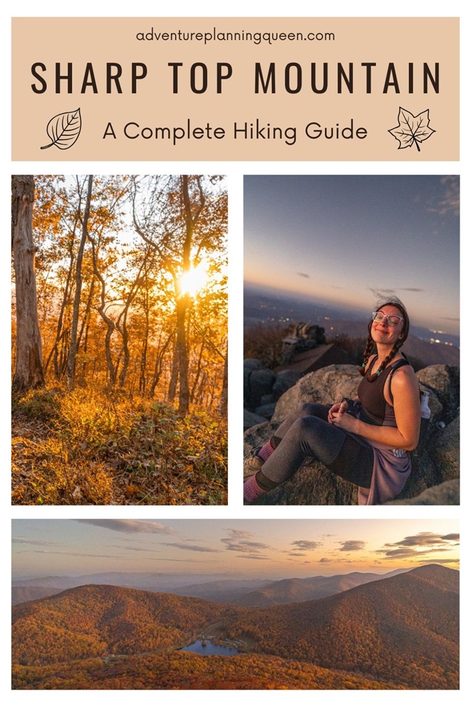
Rising to an elevation of 3,875 feet, Sharp Top Mountain in Virginia’s Blue Ridge Mountains is a popular hiking destination, offering stunning panoramic views that captivate visitors.
Known for its challenging yet rewarding trail, Sharp Top Mountain draws hikers of all skill levels in search of an unforgettable adventure.
The summit’s vistas are particularly mesmerizing at sunrise and sunset, when the surrounding landscape is bathed in a soft, golden light, creating a breathtaking scene.
Sharp Top is the most popular of the three iconic peaks in the Peaks of Otter region, alongside Flat Top and Harkening Hill.
Not only do you get incredible views from Sharp Top’s summit, but the trail passes by Buzzard’s Roost, a rocky outcrop that provides even more stunning views, heightening the excitement of the journey.
In this guide, I’ll cover everything you need to know about hiking Sharp Top Mountain, from trail details, hiking tips, the best times to visit, other nearby hiking trails, and more!
Affiliate Disclaimer: Some of the links below may be affiliate links. Support the blog by signing up or purchasing through those links at no additional cost to you. We greatly thank you and appreciate you all for supporting us!
Sharp Top Mountain: Trail Stats + Map
Sharp Top Trail Stats
Starting Point: Sharp Top Mountain Trailhead
Length: 3 miles
Elevation Gain: 1,300 feet
Difficulty: Challenging
Hiking Time: 2 to 3 hours
Route Type: Out-and-back
Pet-friendly? Yes, must be on leash
Hike Features: Sharp Top summit and Buzzard’s Roost
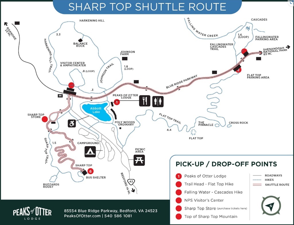
Sharp Top Trail Map
Sharp Top Mountain Trailhead and Parking
Sharp Top Mountain Trailhead is located across the street from the Peaks of Otter Visitor Center off the Blue Ridge Parkway (milepost 86).
The parking area is fairly spacious and can hold about 20-30 vehicles.
Amenities at the trailhead include the Sharp Top Store, restrooms, and drinking water – available seasonally.
If the parking area is full, you can park at the visitor center. Just be careful crossing the road!
🚗 Distance to Sharp Top Trailhead from nearby cities/towns:
- Bedford, VA: About 10 miles (20 minutes’ drive)
- Roanoke, VA: About 30 miles (50 minute’s drive)
- Lynchburg, VA: About 35 miles (50 minutes’ drive)
- Blacksburg, VA: About 70 miles (1 hour and 15 minutes’ drive)
- Charlottesville, VA: About 100 miles (1 hour and 40 minutes’ drive)
Sharp Top Shuttle
The Sharp Top Trail is a challenging hike that might be too demanding for casual hikers or families with young children.
Fortunately, there’s a convenient shuttle bus option that allows visitors to enjoy the breathtaking summit views without tackling the strenuous climb.
🚌 The shuttle offers two choices:
- Round-trip ride up and down the mountain
- One-way trip for those who still want to enjoy a bit of hiking
The shuttle runs seasonally from May through October (schedule subject to change).
It has a set schedule each day and requires a ticket which can be purchased at the Sharp Top Store.
It drops passengers off just 0.25 miles from the summit, allowing for a short but scenic hike to the top.
🚍 For more details, including the schedule and pricing, check out their website HERE.
Best Time to Hike Sharp Top Mountain
The most popular time to hike Sharp Top Mountain is March through November. However, this is a great hike to do year-round with each season offering its own unique experience!
🌷 Spring (March – May)
The trail is surrounded by vibrant wildflowers and lush greenery, creating a beautiful and refreshing atmosphere.
The temperatures are mild, making for a comfortable hike, though it can still be a bit chilly at the summit in early spring.
☀️ Summer (June – August)
Summer offers long daylight hours and vibrant greenery, but it’s also the busiest time on the trail.
Arrive early to secure parking and avoid the crowds!!
While the forest provides shade, the steep climb can be taxing in the summer heat, so bring plenty of water to stay hydrated.
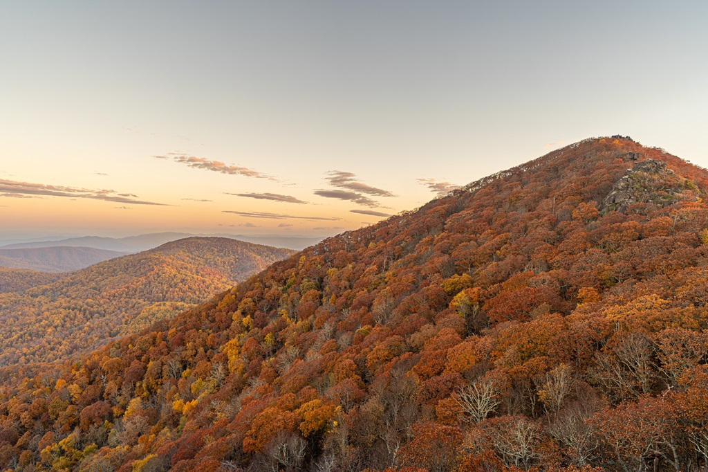
🍂 Fall (September – November)
Fall might be the most stunning time to hike the Sharp Top Trail!
The Blue Ridge Mountains burst into a symphony of reds, oranges, and yellows, providing incredible views along the trail and from the summit.
This season is very popular, so plan for crowds and consider a weekday hike for a quieter experience.
☃️ Winter (December – February)
Winter hikes are serene and uncrowded, with clear, crisp air offering some of the best visibility.
Snow and ice may coat the trail, creating a magical atmosphere but also slippery conditions.
Proper gear, like hiking poles and traction devices, is essential!
In my opinion, fall is the absolute best time to hike Sharp Top, thanks to the breathtaking fall foliage and cooler temperatures.
For a more peaceful experience, try to hike early in the morning or later in the day to avoid the crowds.
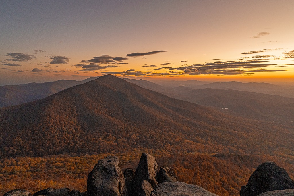
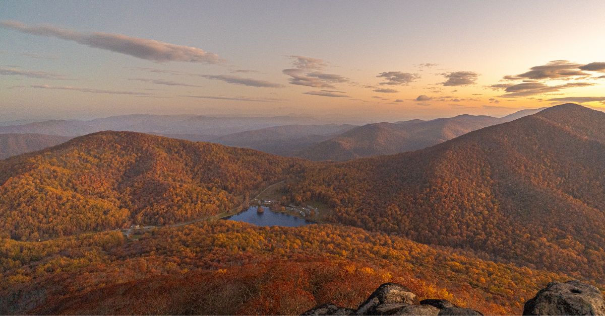
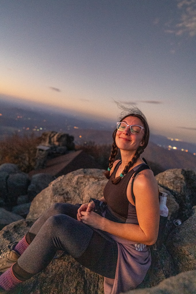
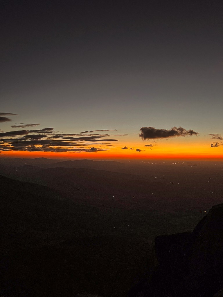
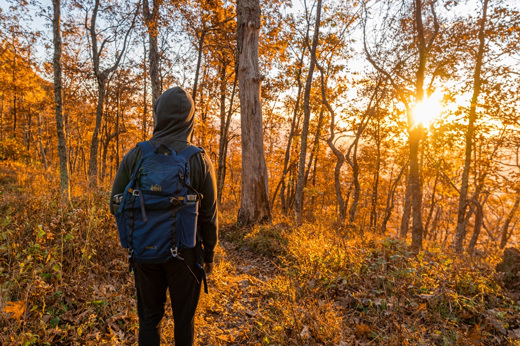
🌄 Sharp Top Mountain Sunrise
I typically say hike early in the morning to avoid crowds, but for this particular hike, watching sunrise from Sharp Top is a popular thing to do.
While it’s not as crowded as later in the day, you can expect a fair number of people at sunrise.
However, the experience is still completely worth it.
My husband and I had the chance to watch the sunrise from Sharp Top’s summit, and it was truly unforgettable!
🌞 Pro Tip: If the summit feels too crowded, take a short hike over to Buzzard’s Roost. It’s just a quick detour from the top, offering stunning views without the crowds.
Sharp Top Trail Directions
Sharp Top Trail
Start your hike from the Sharp Top Trailhead parking area.
The trail can be found to the left of the Sharp Top Store.
You will encounter many steps along the way. But don’t be discouraged, you can do it!
Take breaks, drink plenty of water, and pace yourself.
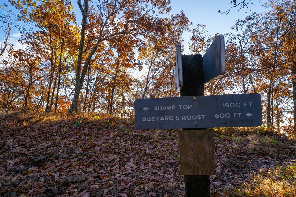
As you make your way up the mountain, you will come to a junction in the trail.
Let’s head to Sharp Top’s summit first – take a left at the junction.
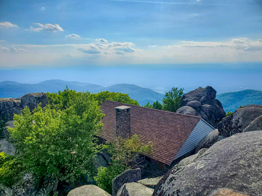
Sharp Top Mountain
As you reach the summit, you will see a stone shelter first along with a sign providing more information about Sharp Top Mountain.
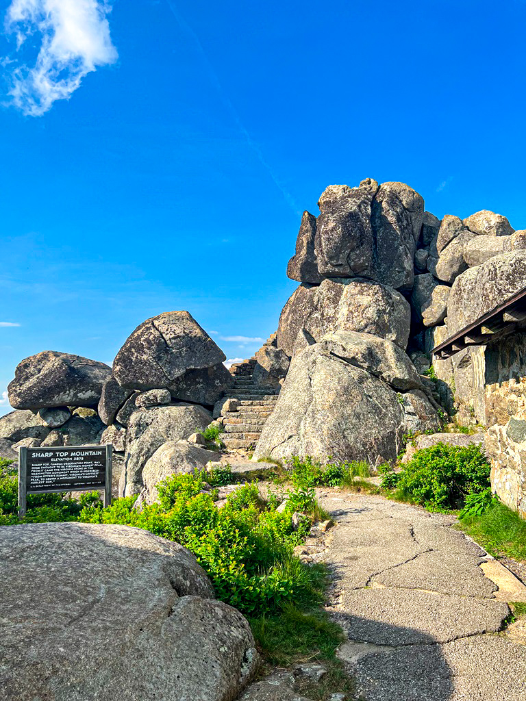
Continue up the steps to find an overlook to the left.
The views are incredible here, but they get even better. Keep going!
At the summit, enjoy 360-degree views of the Blue Ridge Mountains and the surrounding valley.
On a clear day, the sights are breathtaking, making it a perfect place to rest and soak in the beauty of the area.
Sharp Top’s Plane Crash Site (optional)
Here’s a little secret – but keep it to yourself! 🤫
Hidden on Sharp Top Mountain is a World War II B25 bomber crash site.
While I won’t share the exact details on how to find it here, you can check out my dedicated blog post, where I provide all the information you need to locate this historic site.
Now a memorial, the crash site is a somber and significant place.
If you choose to visit, please be mindful of its history and importance.
Respect the area and follow Leave No Trace principles to help preserve this special spot for others.

Buzzard’s Roost (optional)
After soaking in the views at Sharp Top’s summit, head back down to the trail junction to continue your adventure.
For an extra treat, go straight to explore Buzzard’s Roost – one of my favorite spots in the Peaks of Otter area!
To reach the top, you’ll need to tackle a bit of rock scrambling, but the effort is well worth it.
Buzzard’s Roost offers stunning 360-degree views that rival Sharp Top, with far fewer people around to share the space.
Keep an eye out for buzzards circling overhead – it’s likely how this spot earned its name.
They didn’t bother me, so I assume they won’t bother you. 🤷🏻♀️
Retrace your steps back down the mountain to return to the parking area.
Congrats, you made it! 🥳
Tips for Hiking Sharp Top Mountain
1. Start Early: Despite the popularity of watching the sunrise from Sharp Top’s summit, the crowds early in the morning will be more manageable than crowds later in the day.
2. Bring Plenty of Water and Snacks: The hike involves quite a bit of elevation gain, so bring plenty of water to stay hydrated.
Also, bring high-energy snacks to refuel and help maintain your energy during those steep sections.
3. Be Physically Prepared: With a 1,300-foot elevation gain, be ready for a challenging ascent. Take your time and pace yourself.
4. Footwear and Gear:
- The trail involves rocky sections and lots of steps, so wear comfortable, sturdy hiking shoes (or boots).
- Hiking poles may be beneficial on the steep parts, especially when descending.
- Wear proper clothing for the season and bring layers just in case.
- Don’t forget about sun protection!
5. Be Bear Aware: Black bears are active within Virginia’s Blue Ridge Mountains. Follow these guidelines to avoid any negative interactions with a black bear.
6. Respect Nature: Follow Leave No Trace principles – plan ahead, pack out all trash, avoid disturbing wildlife, be considerate of others, and respect the natural beauty of Blue Ridge Mountains.
More Great Hikes Near Sharp Top
1. Harkening Hill and Johnson Farm (Peaks of Otter)
The Harkening Hill loop trail winds through lush forests, leading to a summit with peaceful views of the surrounding landscape.
Along the way, you can explore the historic Johnson Farm, a preserved homestead showcasing Appalachian life in the 19th century.
- Trailhead Location
- Length: 4 miles
- Elevation Gain: 900 feet
- Difficulty: Moderately challenging
- Route Type: Loop
- Hiking Time: 2 to 3 hours
- Pet-friendly? Yes, must be on leash
- Harkening Hill and Johnson Farm Trail Map
2. Flat Top Mountain (Peaks of Otter)
Flat Top, part of the Peaks of Otter, offers a rewarding hike to breathtaking panoramic views.
The trail winds through hardwood forests, showcasing vibrant wildflowers in spring and stunning foliage in fall.
- Trailhead Location
- Length: 4.5 miles
- Elevation Gain: 1,700 feet
- Difficulty: Challenging
- Route Type: Out-and-back
- Hiking Time: 2.5 to 4 hours
- Pet-friendly? Yes, must be on leash
- Flat Top Trail Map
3. Fallingwater Cascades (Peaks of Otter)
Fallingwater Cascades features a picturesque loop trail leading to a stunning waterfall.
Surrounded by lush forest, it’s a peaceful retreat for nature lovers.
- Trailhead Location
- Length: 1.5 miles
- Elevation Gain: 450 feet
- Difficulty: Moderately challenging
- Route Type: Loop
- Hiking Time: 1 to 1.5 hours
- Pet-friendly? Yes, must be on leash
- Fallingwater Cascades Trail Map
4. Apple Orchard Falls
Apple Orchard Falls offers a scenic hike to a majestic 200-foot cascade.
The trail winds through vibrant forests, offering beautiful views and seasonal wildflowers.
- Trailhead Location
- Length: 2.6 miles
- Elevation Gain: 1,000 feet
- Difficulty: Challenging
- Route Type: Out-and-back
- Hiking Time: 1.5 to 2.5 hours
- Pet-friendly? Yes, must be on leash
- Apple Orchard Falls Trail Map
5. Devil’s Marbleyard
Devil’s Marbleyard is a unique hiking destination featuring a massive boulder field surrounded by rugged mountain scenery.
This adventurous trail rewards climbers with stunning panoramic views.
- Trailhead Location
- Length: 3.5 miles
- Elevation Gain: 1,400 feet
- Difficulty: Challenging
- Route Type: Out-and-back
- Hiking Time: 2.5 to 3.5 hours
- Pet-friendly? Yes, must be on leash
- Devil’s Marbleyard Trail Map
6. Hay Rock
Hay Rock offers a scenic hike along the Appalachian Trail, featuring sweeping views of Carvins Cove and the Roanoke Valley.
The trail is perfect for nature lovers and photography enthusiasts.
- Trailhead Location
- Length: 8 miles
- Elevation Gain: 1,500 feet
- Difficulty: Moderately challenging
- Route Type: Out-and-back
- Hiking Time: 4 to 5 hours
- Pet-friendly? Yes, must be on leash
- Hay Rock Trail Map
7. McAfee Knob
McAfee Knob, one of Virginia’s most iconic hikes, features a stunning rock overhang with panoramic views of the Catawba Valley.
It’s a must-see spot on the Appalachian Trail!
- Trailhead Location
- Length: 8 miles
- Elevation Gain: 1,800 feet
- Difficulty: Challenging
- Route Type: Out-and-back
- Hiking Time: 4 to 6 hours
- Pet-friendly? Yes, must be on leash
- McAfee Knob Trail Map
Conclusion
Sharp Top Mountain is an iconic destination in Virginia, offering both a physical challenge and unparalleled views from the summit.
Don’t miss the detour to Buzzard’s Roost, a quieter spot with stunning vistas and a touch of solitude.
Whether you’re an experienced hiker or a beginner looking for a new challenge, Sharp Top promises an unforgettable experience!
If this guide inspires you to hike Sharp Top Mountain, I’d love to hear about your adventure.
Leave a comment and share your experience!
Enjoyed this post? Pin for later!